Friday, August 22, 2008

Parties and Wilderness!!!!

No time No time No time -- to post on my blog..........it's been a full week of family with a few days of adventure.

Family --- Birthday party at The Hill for Griffin Lind (4) and Micheal Murphy (51) on Saturday/Sunday (Aug 16-17).


Along with loads of yummy food, kid play, fire dancing, and camping over,,,,,,,,we also had a visit from some old friends.
Including Lew Barkley -- a resident of The Hill when I was just a little girl -- stopped by on a road trip up the west coast. Along way from his farm in Michigan but also a bit like coming home. Quite a treat!

Lew Barkley and Pollyanna Lind -- The HILL

Adventure -- Monday-Wednesday (Aug 18-20) my younger bro (Gabby), our friend Aaron, and I loaded up our backpacks and headed into the Bull of the Woods Wilderness for a few days. Hiked in on the trail from Elk Lake for a few miles then did our usual -- hopped off trail to find a camp site and then spent our days using the creek beds that cut through the steep forested mountains as our pathways to explore. Old growth Cathedral forests, Bedrock pools of aqua blue and an 80 foot waterfall in the middle of it all were our rewards.


It rained like crazy our last night and day. Got home soaked and happy.

Aaron Varela, Gabby Lind, Pollyanna Lind --
soaked in the rainforest of Bull of the Woods Wilderness

Yesterday and Today are all about getting ready to head back out to the Middle Fork John Day for our last 12 day stint of field work for the season. No guarantee that I'll have internet access this time around in the MFJD..........if yes, you'll hear from me........if no, the blog will be updated upon my return.

Wednesday, August 13, 2008

Eugene -- Bro Gab in town - BDays!

Back in Eugene ........ the west side of the Cascades. Green is the color even in the driest month of summer, the big rivers flow, and the nights are warm. As much as I appreciate and enjoy the beauty of eastern Oregon I am reminded once again that the west side is home. I am soothed by the lush understory of the forests and moist warm night air.

Lots of data organizing to do from the Middle Fork John Day field work stint but also trying to soak up some family/friend time while I am back in the "hood." My time here in Eugene is short before I head back out to the MFJD and it seems as though I have packed it full.

Monday I washed and organized myself, my gear, and all the field gear. A serious time consuming job.

Gabby, Missy and Griffin arrived on Tuesday afternoon via the Portland airport and gramma and grampa's door to door delivery taxi.
It feels so good to be around these folks! I am a bit bummed that I have to do some work time during the day while they are here because I would like to spend every minute them.
I feel more comfortable around my brother Gabby than most people in the world. It's a sort of familiarity that some close siblings get to know. I appreciate it beyond words.
THE GOOD NEWS: Gabby and family will be moving back to Eugene from Virginia within the year!!!!!!!!!! Yeh.

Monday (8/11) was my darl'en friend Betty Kim Koeppen's birthday (check the link and hear her music). Words can't express the value of her friendship and the creativity that she brings to the world. She has been counted as one of my best friends for the past 25 years. She is a musician, a writer, a dancer, a mom, a teacher, a good good good friend.

Tuesday (8/12) was also my friend Scott Freitas' birthday. I have been friends with this loopy fantastic fellow for 22 years. Never a dull moment .... always good friends ... even when large and small time and space has passed between us.

Shawn Johnson, Scott Freitas, Pollyanna Lind -- Scotty's b-day.
Where is our Kimmy!!!

Today is my brother Jon's birthday. Enough said. He is basically as cool as it gets!

Saturday, August 9, 2008

FOREST FIRES on the MFJD

hey hey Yeh --

Remember the thunderstorms I mentioned on Thursday with lightening, etc. Well, by Friday sunrise there were fire planes buzzing the mountains that flank the Middle Fork John Day valley.

By mid-day the valley where we are was pretty smoky and we saw Forest Service fire rigs and crews of firefighter's going up the road behind the property we are staying at. The ridge on the other side of the valley, Ragged Ridge, had a small visible fire in a steep high canyon section -- helicopters with huge buckets of water were trying to douse it. Then, a big cargo copter with "hot-shots" came in (buzz'en super close to us for some reason while we were working on the river) and they repelled out of the copter directly into the blazing canyon to do ground based fighting. The fire on our side of the valley was super smoky. We didn't have any internet service yesterday (and no phone as usual). So, after a dinner that was dusted with ash back at base camp, we drove up the road the firefighter rigs were headed up to check on the situation. Would hate to find ourselves sipping tea and unwittingly have a raging forest fire come upon us.
We drove up to the road closure (about 2 miles from camp) where we talked to a few fire fighters that gave us the scoop == the fires had been contained (they had a bulldozer fire line dug around the thing) and would be burning itself out. We could see the fire and the dusk-time darkness gave us a good view.

Pollyanna check'en out the fire

Today more firefighter crews came up the road -- to do "mop up" and make sure the main blaze didn't get past the perimeter.
WAY less smoke today...........but my tent was dusted in ash this morning.

As far as work goes: we set our methods for doing fish cover surveys yesterday and went about doing them today as well. A fish cover survey is where percent area covering the surface of a stream or stream bed is estimated (what percent of the stream is available fish cover?). We look at all sorts of variables like aquatic or emergent vegetation, woody debris, boulders, built structures, algae, etc. For this project we are doing these surveys in representative pools and glides across 4 reaches of the river. We also measure maximum and minimum depth of the geomorphic channl unit that we are doing the survey in.

Here's Steph giv'en it her all! for max depth.

We have been out here working since July 27th.........heading back to Eugene tomorrow after a 1/2 day's worth of work. Not looking forward to the 6+ hour drive but looking forward to seeing Steve and my brother Gabby. Gab is coming to visit from Virginia for 9 days with his family..........and I Can't wait to see him! We are going camping for a few days in the mix too. YEH!
I'll be coming back out to the MFJD on August 23rd.

Thursday, August 7, 2008

Thunderstorms!

Hey Hey ---

It's Wednesday night and we have had about 24 hours of off and on thunderstorms here in the Middle Fork John Day.

It all started with a magnificent sunset last night


Then at about 10pm the lightening started. With it came the crash and roll of thunder and rain. Ah, those sounds of nature that make my spirit smile. Just a couple of lite rains during the night and today we have had a few more lite ones and a couple of heavy rains.............all complete with bolt lightening, high winds, and giant warm rain drops. The storms move in fast and leave fast.............settling the dust and smells of summer into a fresh lull of sweetness that currently surrounds me. It's dark and the sky is full of stars. The moon rests in the southern sky,,,,growing by the day. No rain right now but thunderstorms are forecast for the next 24 hours. We have camp all buttoned up just in case.

Today was "easter egg hunt" day -- or perhaps "find a needle in the haystack" day. We went on the search for 18 US Bureau of Reclamation survey control points spread through the Upper Middle Fork valley. We found all of them -- and all but a couple were in good usable shape (one was totally destroyed). It is important to find the control points so we can tie our survey work into theirs. This makes it a whole lot easier to set our survey transects up and correlate our data to theirs and any future survey work. A few times the wooden stakes that had been pounded flush to the floodplain two years ago by USBR survey crews were easy to find. Mostly, it was a hunt through eye-ball tall grass where silty over-bank flood deposits had covered the small nail and the sun-faded flagging tape attached to the top of the stake. We made it fun -- of course -- and ended up having a really good day.
The last 1/3 of the day was spent designing a methodology for fish cover stream surveys based on NAWQA and Forest Service guidelines for stream surveys. We'll give it a try tomorrow and make changes as needed --- more in the future on this one.

SO -- we finished the gravel counts and the embeddedness surveys as well as the channel unit mapping and river reach photo documentations. YEH! The most tedious job of these tasks was recording the data from the gravel count/embeddedness surveys. But, we made it good by rotating out who had to do the recording and by setting up a chair in the river for the data recorder. ODE TO US!
Jess


Polly


Steph!


Big Arse gravels out in these parts. No pansies allowed on these gravel (boulder) counts! (Jess & Steph)


Walk'en the riffle transect line -- pollyanna

Tuesday, August 5, 2008

Day OFF and working toils

The moon is starting to wax!!!!!

Friday - August 1st was the NEW MOON. That's the night that Steve arrived and the night that the super great property manager here on the Warm Spring Tribal land of the Middle Fork John Day took us on a tour of the stars -- literally. Using his personal telescope we were able to see the four primary moons of Jupiter, a couple of nebula, two galaxies (including Andromeda galaxy) and heaps and heaps of other stars.

Saturday -- was day off out here at base camp. We all slept in, made a yummy breakfast of eggs and banana pancakes and then enjoyed the day. Steve and I took advantage of not having the thousands of projects that keep one busy when you have a day off at home and walked around the country side here a bit. Mostly enjoying each other's company and the scenery.

It was fabulously wonderfully fantastic to have Steve visit.
If anyone else is hankering for a bit of this very interesting land out here in the middle of nowhere else, let me know and I'll give you directions and my schedule. Heaps of hiking/mountain biking/camping to be done within minutes of where I am based.

One of the many view from Vinegar Hill (from Jess and Steph's hike on Saturday).

Back to work on Sunday ....... and Monday ..... and today (Tuesday). The crew out here is working well together. We should be finished up with gravel counts, embeddedness, channel unit mapping, and photo documentation of our four main reaches by mid day on Thursday. Then it's on to fish cover surveys................more about that later!
To add to our entertainment a group of 5 Oregon State University graduate students arrived to do a few days of work on their stream temperature study. We had the sounds of a banjo next to the fire pit last night.

Friday, August 1, 2008

Mapping and Counting

It has been a very busy few days here on the Middle Fork John Day. Pretty much busy from sunrise to sunset. I have been wanting to post parts of my day but just couldn't find the time until now.

The weather continues to be absolutely amazing! crisp and very chilly at night and in the mornings then it gets in the low to mid 80s during the day.

Geomorphic data collection on the MFJD is going well. The last couple of days have been focused on gravel counts; embeddedness measurements; stream unit mapping; and photo documenting the four primary river reaches we are working on -- complete with GPS.

I think I talked about gravel counts earlier (July 29th).
Embeddedness is related to how much water flow and aeration occurs around the gravels and cobbles on the bed of a stream. The more embedded, the less flow and aeration. Flow and aeration around gravels and cobbles is necessary habitat for successful fish egg development.
Stream unit mapping means identifying all the riffles, pools, and glides in a river segment (usually not visible in photos or even from the bank in the detail we are recording). Complexity is necessary for healthy aquatic habitat and river function.

Stephanie and Jessica work'en on the MFJD -- with coyote bluff in the background.

While I have been doing the stream unit mapping my cohorts (Stephanie and Jessica) have been photo-documenting the river in photo sets that are GPSed. This will be used for historic comparisons in the future.

So that's that!!!

Today we finished four gravel counts and embeddedness measurement sets on our uppermost river segment. These things take a lot of focus as there are literally over a hundred per riffle that is done and each is maticulously recorded.

We had a "force of nature" experience today as we were getting close to finishing our data collection on the last riffle. Some might have called it a dust devil -- it formed just 100 meters away from where we were working on an old quarry site. This thing ended up being around 200 feet high and about 100 feet across. It formed rapidly, picking up dust, pebbles, and sticks up to 1 foot long. It was solid debris. Luckily we were in the channel so we were slightly lower than the surface it formed on. Still, we were pelted with sticks and rocks as it moved quickly over us. No injuries except a couple of little scratches. It dissipated as it went into the lodge pole pines at the edge of the valley.

But, we finished up early. This gave Jessica and I time to hike up to Lemon Cabin -- it'an old miners cabin about 2.5 miles up on an abandoned (closed off to motor vehicles) Forest Service road. We ran all the way back down the mountain and plunged our sweaty heads in the creek before heading back to camp.

Granite Boulder Creek

Now, here I am. The sun is low in the sky but still very warm. Steve (my fantastic beau) just arrived for the weekend. And, it's time to make dinner!

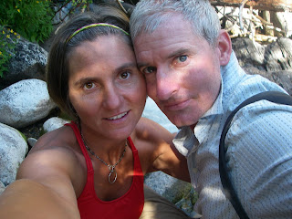
Pollyanna -- not worried about unflattering photos.

Flower of the day -- anyone know what this one is called? They are tiny!