After taking down camp we visited the "control reaches" we picked for the MFJD. Baseline data will also be taken of the control reaches, just like the reaches that are going to have restoration work done on them. This allows us to better monitor changes at the restoration sites related to restoration projects compared to changes that the entire river may experience (floods, droughts, landslides, etc).
Then, it was time to start the trip back to the west side. It is a long 6+ hour drive from base camp to Eugene.
To break up the drive we made a couple of side stops.
 Petroglyphs near the John Day River
 Picture Gorge -- John Day River -- awesome swimming hole!
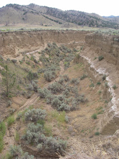
 Meyers Canyon (Ochoco Mountains) -- erosive flash flood arroyo -- the white stratigraphic layer is Mnt Mazama (Crater Lake) eruptive volcanic ash (7,700 years old).
Today is a day of gear sorting and washing.
Have to start getting ready to go to Michigan (FAMILY REUNION!)

1 comment:
Your photos are right out of the movies. Beautiful!!
Jacinda
Post a Comment